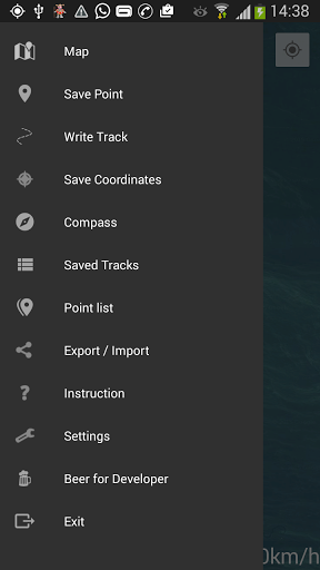
Convenient saving and searching for your geopoints, recording tracks, offline maps (fishing, historical, topographic, your own) it's not a full list of the main functionality of the app.
The application has been created for the most convenient and easiest navigation in the fishing conditions. Later, this application was also liked by treasure hunters, mushroom pickers, tourists, hunters, etc. The creator of the application is a fisherman himself, and initially, the application has been created for personal usage, because of lack of usability in previously tested apps.
We decided to share our app with the improved user experience and hope you will like it.
Features:
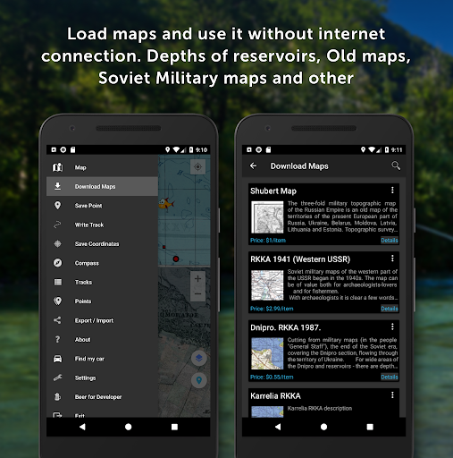
- Any kinds of Offline Maps for every taste: fishing (with depths), historical (Schubert, Mende, Red Army), topographic (General Staff, Open Street Maps) and others
- Use your maps offline ( ozf, ozf2, mbtiles formats)
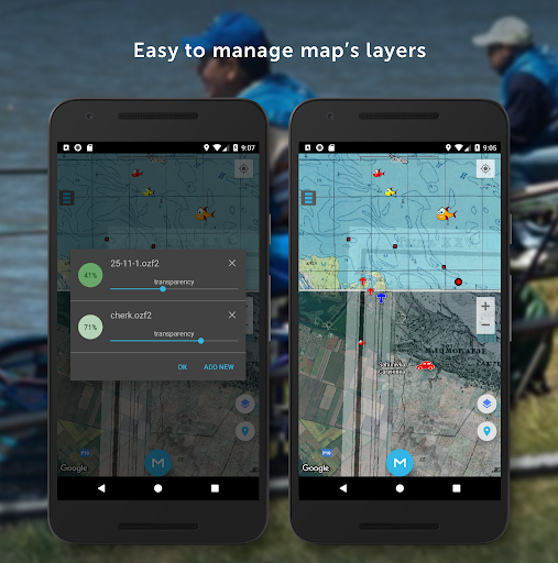
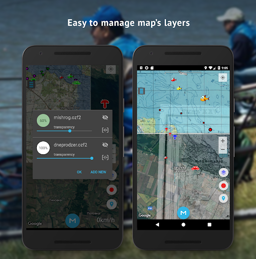
- Convenient work with layers (you can place several layers above the map and set them different transparency)
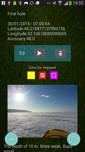
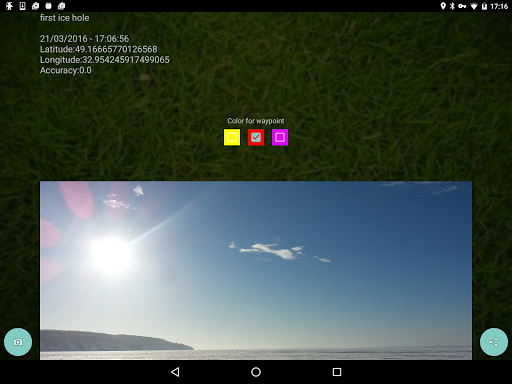
- Show the coordinates, and their accuracy
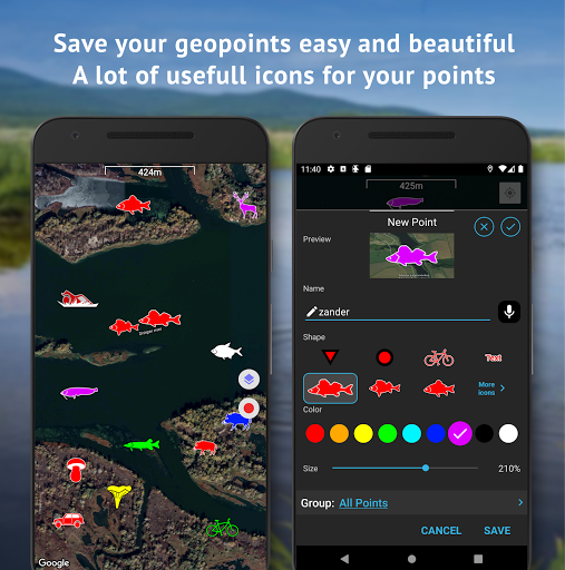
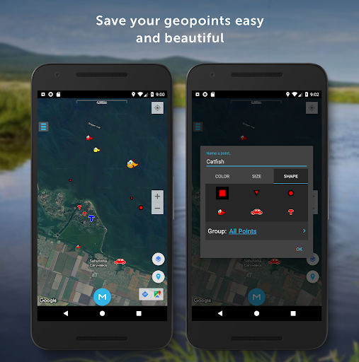
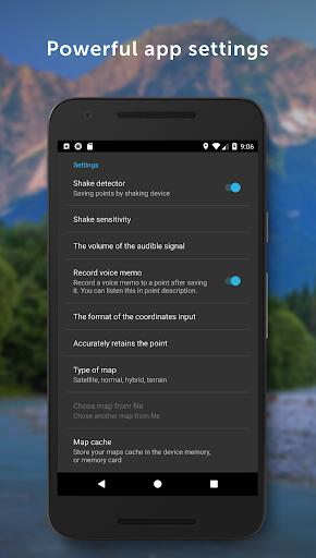
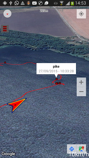
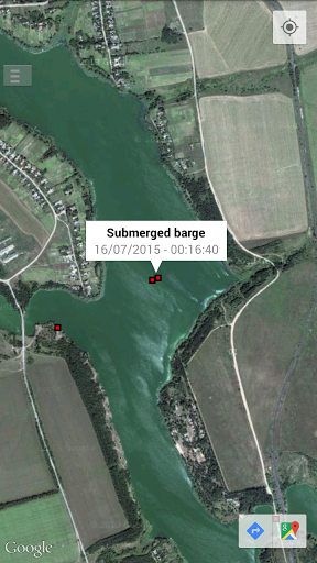
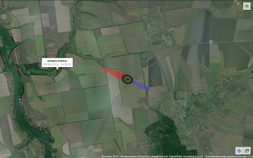
- Save geopoints when shaking the phone. Set geopoints different colors, shapes and sizes.
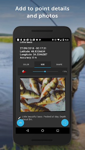
- Records a sound comment to the geopoint after saving, which you can listen in the description of the geopoint.
- Take a photo to the geopoint that will be shown in the description of the geopoint.
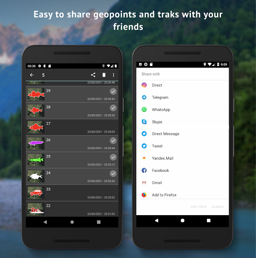
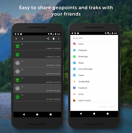
- Send geopoints via SMS, mail or any other way
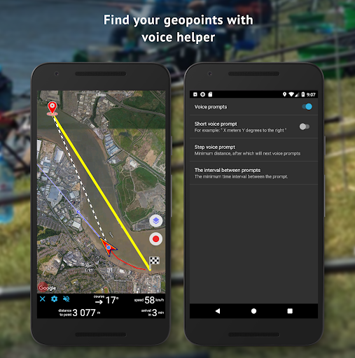
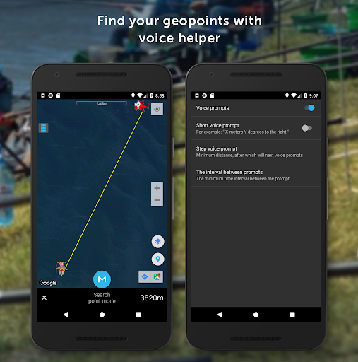
- Geopoint search mode by voice prompts.
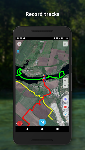
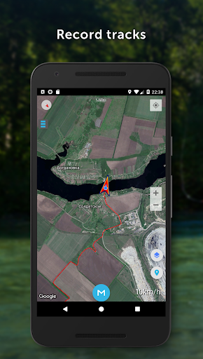
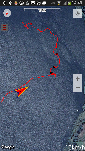
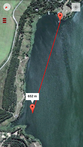
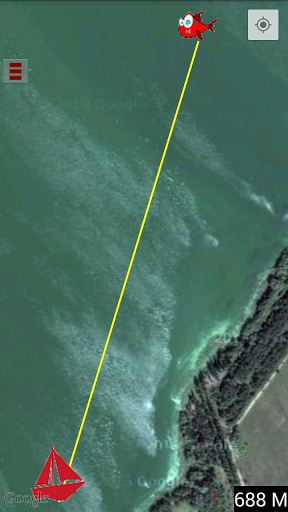
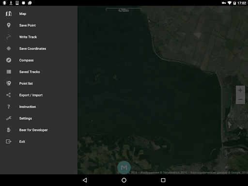
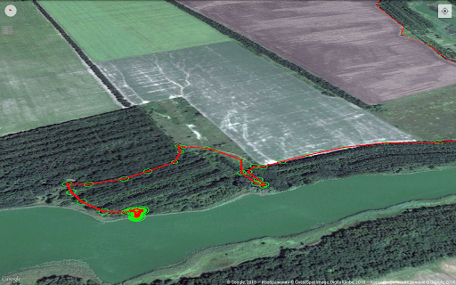
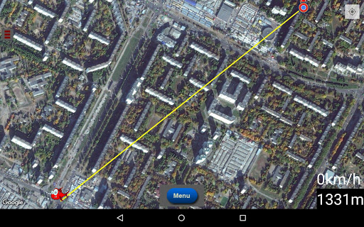
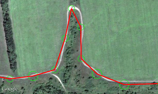
- Records a movement track
- Shows a map and your location on it
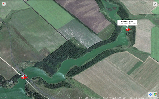
- Shows saved geopoints and tracks on the map
- Shows the accuracy of the geopoints, in the circle in which it is located
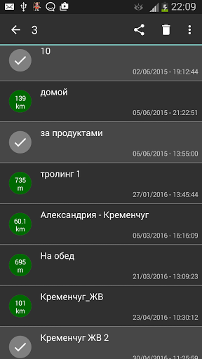
- Allows you to name and give detailed descriptions of geopoints and tracks
- Convenient geopoints search by clicking on it
- Ability to export and import geopoints and tracks in gpx format
- Sync points with the cloud, backup
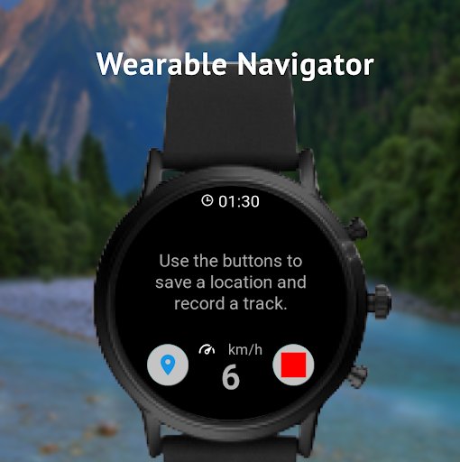
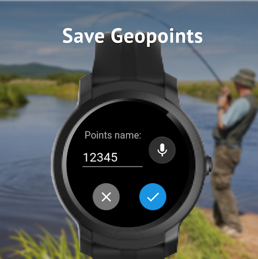
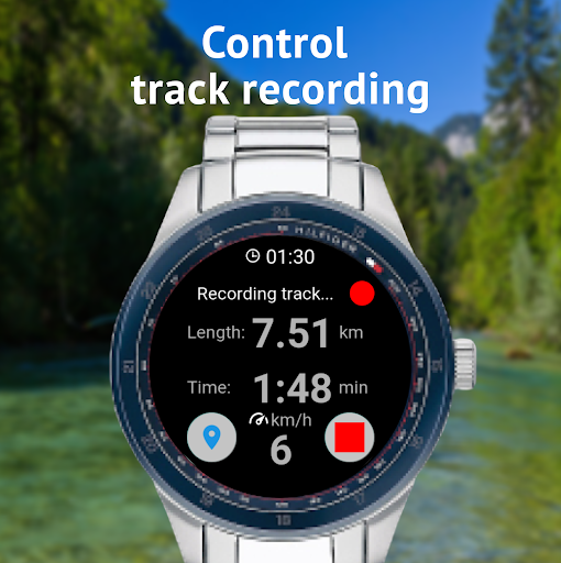
Now added support for Wear OS smart watches. You can save point and control track recording by interactions with your watches!
In the future upgrades we are planing additional features:
- easy and convenient navigation to the geopoint
- offline maps
- ability to view track on the map
Our web site with FAQ and other useful information - https://sites.google.com/view/susaninnavigator/faq
To quick support use our Telegram @susanin_support or Email zakorchook.play@gmail.com
Subscribe to our Telegram channel to stay in touch and get the latest updates:
https://t.me/navigator_susanin_en
Our Instagram:
https://www.instagram.com/fishermannavigator
We are always open to your ideas and suggestions! What other tutorials are needed? what features would you like to receive in the next versions of the application? what comments you have to existing functions - do not hesitate, write in reviews or by mail.
Enjoy and don't hesitate to ask us anything. Good luck!
- Fixed issue with storage permission
- Other fixes and improvements
Fixes and improvements
Filter for your points by tags and time frame
● Point groups now is presented as a Tags
● Now you can set to one point more than one Tag
● Improved UI of Tags
● Bug fixing and performance improvement
- Settings for cursor colour and size
- "Rings of distance" around cursor
- Now you can more than one photo to the point.
- Improvements and fixes.
- Some fixes and improvements
-New depth maps of Dnipro
-One more map for Ob sea - Tula
-Improved interface of change layer's transparency
-New depth maps of Dnipro
-One more map for Ob sea - Tula
-Improved interface of change layer's transparency
-High resolution offline satellite maps
-Faster load of new point's icons
-Improved performance of mbtiles maps
-Fixed issue with SD card recognition
-Improved view of the track
-A lot of other improvements and fixes
- Fixed issue with opening by the app txt, pdf and other, not related with the app files
- Fixed issue with connection and other small issues with the Wear OS app
- Correct handling complex cases with own maps import
- After maps import, source files not deleting by default, but only if user checked the checkbox
- fixed issue with downloading depth maps of Ob river
- improved import own maps (now you able to use subfolders)
- added ability to import mbtiles map by click to mbtiles file in Files app or other file managers
- other fixes and improvements
-Good quality depth maps of Ob sea (other water will added soon)
-Migration to Android 11
-Fixed issue with redundant windows after first launch
-Other fixes and improvements
- Hot Fixes bugs from 1.56.0
Fixed old bug with wrong squares on ozf maps.
- Added "+ -" buttons for more convenient selection of geopoint size and track width
- Added the ability to navigate in 3D map mode
- Fixed some bugs
-Maps of Far East
-Settings of track recording
-Hold finger on the "layers" button make all layers transparent
-Copy coordinates from point's menu and map long press menu
-Other fixes and improvements
-Maps of Far East
-Settings of track recording
-Hold finger on the "layers" button make all layers transparent
-Copy coordinates from point's menu and map long press menu
-Other fixes and improvements
-new various pictures for geopoints
-more convenient interface for saving points
-added the ability to search for available maps nearby
-Improved the ruler at the top of the map
-Sorting in lists of points, tracks and routes by date, alphabet and distance
-Load satellite maps for offline use
-Navigation to geopoint is implemented for smart watches
+hot fixes
- Improved Ruler (polyline measurement)
- Work with Routes (create, show on the map, edit, etc.)
- Other fixes and improvements of the app stability
- Hot fixes database upgrade
- Improved Ruler (polyline measurement)
- Work with Routes (create, show on the map, edit, etc.)
- Other fixes and improvements of the app stability
- Improved Navigation to geopoints
- Improved work with map layers
- Companion app for smart watches Wear OS
- Fixed track recording, picking users offline map from device files, and other issues with android 10
- Other fixes and improvements
- Improved Navigation to geopoints
- Improved work with map layers
- Companion app for smart watches Wear OS
- Fixed track recording and other issues with android 10
- Other fixes and improvements
- added to map button for record track
- full-screen mode by tap to the map
- reduced app file size
- fixed google maps bug!
- Added to Download Maps FREE offline maps!
- Improved save point flow by long press to map
- Parsing coordinates in different formats from text
- Other fixes and improvements
- Improved accuracy of coordinates for "save point" feature
- Ability show multiple treks at once
- Other fixes and improvements
- Ability to switch screen orientation from the Settings (portrait/landscape)
- New offline maps
- Sync your points with Google Drive.
- New Maps (Kamchatka)
Details: https://sites.google.com/view/susaninnavigator/1-44
- new cool point's icons
- fix issues and improve download map feature & new maps to download
- improve search point mode
- other minor fixes
Upgraded "Search point mode"
Improvements and fixes
Improvements and fixes
- Added support for OZF maps.
- Added layers button to the map.
- Added About screen with mutch usefull informatio for users.
- Fixed length of coordinates value (was very long number, now 7 symbols after dot)
- Added abbility set Group to geopoint bewore saving.
- Fixed many small issues.
Fixed few small issues
- fixed problem with offline maps- improved mode "map rotation"- fixed issue with take photo for geopoint
- set different sizes,shapes,colors for location-points- Simplified renaming of the point after saving it- mode"rotation of map in the direction of movement"- Significantly improved and simplified feature "share point".Now the point can be equally effectively divided by SMS and all other available messengers- Fixed a problem with the inability to set and store coordinates with a negative value(relevant for the southern hemisphere)- Added experimental function-"search for a parked car"
- more info in treks description- updated ruller- fixed bug for layer's transparency for mbtiles layer
- improved lists of treks and points- added ability sort points and trek into different groups- added button to save point on Map- now the button "Map Menu" can be added by yourself- another fixes and optimisations